Hurricane Isaias forecast to become 90 mph storm; hurricane watch issued for Florida's east coast
- Heavy rain associated with Isaias could arrive in South and east-Central Florida tonight.
- Tropical storm conditions possible along Florida's east coast starting Saturday.
- Tropical storm watch in effect for Ocean Reef to Sebastian Inlet and Lake Okeechobee.
BREVARD, Fla. – Hurricane watches are in effect for the east coast of Florida as Hurricane Isaias weakened slightly, with winds dropping to 75 mph as it moved toward a likely weekend arrival offshore, according to the latest advisory from the National Hurricane Center.
Earlier forecasts that Isaias could become a Category 2 hurricane Saturday have been revised. Winds are now forecast to reach 90 mph by the time it approaches Florida, which is Category 1 strength.
The NHC said Isaias is forecast to move near or over the Northwestern Bahamas Saturday and near the east coast of the Florida peninsula Saturday afternoon through Sunday.
The east coast of Florida is in the forecast path of the large hurricane and some models show the eye coming ashore or brushing the coast, according to the Florida Public Radio Emergency Network.
Hurricane Isaias:How did the storm get its name, and how do you pronounce it?
Strong winds and heavy rain, along with dangerous beach conditions, are possible along coast over the weekend, according to the National Weather Service, Melbourne.
The hurricane service said the eastern Carolinas could feel the effects of the hurricane by early next week, with heavy rains and isolated flash and urban flooding.
Tropical storm conditions are possible in the watch area in Florida beginning Saturday.
- Location: 245 miles southeast of Nassau
- Maximum sustained winds: 75 mph
- Movement: northwest at 16 mph
- Next advisory: 5 p.m.
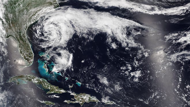
At 2 p.m. EST, the center of Hurricane Isaias was located 245 miles southeast of Nassau.
Isaias is moving toward the northwest near 16 mph, and a generally northwest motion with some decrease in forward speed is expected for the next couple of days, followed by a turn toward the north-northwest.
More:See live beach cams from Puerto Rico, Virgin Islands
On the forecast track, the center of Isaias will move near or over the southeastern Bahamas today.
Isaias is forecast to be near the Central Bahamas tonight, and move near or over the Northwestern Bahamas and be near or east of Florida on Saturday and Sunday.
Maximum sustained winds are near 75 mph, with higher gusts.
Some strengthening is possible today, and Isaias is expected to remain a hurricane for the next few days.
Hurricane-force winds extend outward up to 35 miles from the center and tropical-storm-force winds extend outward up to 205 miles.
The estimated minimum central pressure is 991 mb.
What impact will Hurricane Isaias have on Florida?
Hurricane conditions are possible across Florida over the weekend. The National Weather Service, Melbourne, said impacts to east-central Florida include:
- Strong tropical storm to hurricane-force winds will be possible along the coast over the weekend, especially the barrier islands.
- Squalls with wind gusts of 35-65 mph possible, with the highest winds near the coast.
- 3-5 inches of rain, mostly along the Treasure Coast
- Dangerous beach and marine conditions are expected.
Gov. Ron DeSantis Wednesday encouraged everyone to prepare by having at least seven days of supplies. #Disaster supply kit checklist
"The U.S. will only get skimmed in Florida and the Carolina coastline with the only possible landfall along the Carolina coast early next week," AccuWeather Senior Meteorologist Alan Reppert said.
"It will be losing wind intensity by that time though, but it still will bring rain, wind and rough surf, especially to the Florida and Carolina coastline."
AccuWeather Senior Meteorologist Rob Miller cautioned that people should not focus on just the eye path given the sweeping size of Isaias.
Torrential downpours, gusty thunderstorms and building seas are likely to precede Isaias by as much as 24 hours, which means that tropical storm conditions will spread northwestward across Cuba during through early Saturday and should begin in Miami during Friday night or early Saturday morning.


Hazards affecting land
Storm surge: A dangerous storm surge will raise water levels by as much as 3 to 5 feet above normal tide levels in areas of onshore winds in the Bahamas.
Wind: Tropical storm conditions will continue across portions of the Dominican Republic, Haiti, and the Turks and Caicos this morning. Hurricane conditions are expected to begin in the southeastern Bahamas this morning and spread into the central and northwestern Bahamas tonight and into Saturday.
Rainfall: Isaias is expected to produce the following rain accumulations through Saturday:
- Dominican Republic and northern Haiti: 4 to 8 inches, with isolated maximum totals of 12 inches.
- Bahamas, Turks and Caicos: 4 to 8 inches. Cuba: 1 to 2 inches, with isolated maximum totals of 4 inches.
These rainfall amounts will lead to life-threatening flash flooding and mudslides, as well as river flooding.
From Friday night through Monday: South Florida into east-Central Florida: 2 to 4 inches, with isolated maximum totals of 6 inches.
These rainfall amounts could result in isolated flash and urban flooding, especially in low-lying and poorly drained areas.
Heavy rains associated with Isaias may begin to affect the eastern Carolinas by early next week. This rain could result in isolated flash and urban flooding, especially in low-lying and poorly drained areas, as well as isolated minor river flooding.
Surf: wells generated by Isaias are affecting portions of Puerto Rico, the Dominican Republic, the Turks and Caicos Islands and the southeastern Bahamas. These swells will spread along the coast of Cuba and into the central and northwestern Bahamas later today and along the east coast of Florida on Saturday. These swells are likely to cause life-threatening surf and rip current conditions.